The TNQ Drought Hub is encouraging and supporting honours students through scholarships (full time and top-up) to conduct regionally focused drought resilience projects that will build academic knowledge in the agricultural sector.
Remote Monitoring of Water Levels and Volumes in Australian Wetlands and Water Bodies: A Multi-Satellite Approach
Student: Lily Lewis
Academic Supervisor: Dr. Ben Jarihani
Research Questions/Objectives:
This Honours project seeks to develop and validate methodologies for integrating SWOT satellite data with other altimetry and optical datasets to monitor and analyse inland water dynamics. The study will focus on:
Developing a methodology for interpreting SWOT satellite data with other altimetry and optical datasets for monitoring inland water bodies and validating satellite derived surface elevations and volume estimate using ground-based observations where possible.
Delivering actionable insights for optimizing irrigation and water management practices in drought-prone agricultural and coastal wetland areas.
Research Questions:
How can SWOT and other satellite altimetry datasets be utilised to accurately monitor inland water dynamics in drought-prone areas of Northwest Australia?
What is the precision of integrated altimetry and optical satellite data in mapping water bodies in arid and semi-arid landscapes?
What are the relationships between water availability, agricultural land use, and grazing practices in Northwest Australia? And how do these change with seasonal and long-term water availability?
How can satellite-derived hydrological data inform drought resilience strategies for agricultural and grazing communities?
How can satellite technology enhance long-term water resource management to mitigate the impacts of climate variability in the region?
Brief Description of the Project:
This honours project aims to use the SWOT satellite, along with other altimetry and optical satellites, to monitor and map inland water dynamics in Northwest Australia—a region that frequently experiences severe droughts—as well as wetland areas and agricultural lands in coastal regions. By analysing water surface elevations, volume changes, and the relationship between water availability and land use, this project will provide valuable insights into hydrological dynamics for agricultural, grazing, and wetland management. The study will also explore applications in sugarcane and horticultural farming in coastal areas. The integration of multiple satellite datasets will contribute to sustainable water management strategies, supporting resilience in the face of droughts and benefiting agriculture, grazing, wetland conservation, and horticultural practices.
Background and Significance of the Research Question to drought risk, vulnerability, preparedness, or resilience:
Ground-based monitoring on inland water bodies via gauge stations has declined significantly over the last four decades primarily due to high costs, insufficient observational coverage, and low accuracy. With the continuous development of remote sensing technologies, satellites will become increasingly more important for monitoring inland water bodies. Surface water and ocean and ocean topography (SWOT) satellite provides continuous monitoring of the elevation of ocean and land water levels with high accuracy, temporal resolution, and spatial coverage. The publicly available data has ground-breaking applications for monitoring meteorological changes and agricultural management, including drought resilience and preparedness. This data can used for tracking and modelling drought risk in drought-prone areas such as North-Western QLD.
Academic and research experience relevant to the honours project:
I have completed a Bachelor of Marine Science at JCU, focusing on physical oceanography, coastal and catchment geomorphology, and remote sensing. I acquired relevant skills in surveying and GIS among other programs relevant to the project. Additionally, I have volunteered in the field with my supervisor Dr. Ben Jarihani on an agricultural and wetland restoration project.
Principal Supervisor’s skills and experience in relation to this project topic:
Dr. Ben Jarihani is a highly accomplished Water Engineer and Hydrologist with an extensive career encompassing Irrigation and Drainage Engineering, Water Resources Engineering, Hydraulic Design, Geomorphology, Soil Erosion, and Wetland Modelling. Dr. Jarihani’s professional experience encompasses academia, teaching, research, and consultancy.
Dr. Jarihani’s commitment to advancing the field is evident through substantial contributions to environmental modelling. His comprehensive expertise underscores his ability to address the intricate dynamics of aquatic ecosystems. Dr. Jarihani has garnered recognition for specific achievements and projects across these diverse domains, attesting to the depth and breadth of his contributions. Dr Jarihani is involved actively involved in projects encompassing spatial hydrology and the application of remotely sensed data and GIS in hydrological and hydraulic modelling.
About me
My name is Lily, and I am 25 years old with an undergraduate degree in Marine Science. Growing up in Lennox Head, I was always drawn to the ocean—surfing, diving, and exploring the coastal environment fostered my deep appreciation for marine and aquatic systems. I chose to study marine science because I wanted to turn that passion into a career. While marine biology often takes the spotlight, I was more captivated by the physical processes that shape our oceans—currents, waves, sediments, and hydrodynamics.
I am currently undertaking my honours research with Dr. Ben Jarihani, focusing on the application of remote sensing technologies to measure water surface elevation in small, intermediate, and large inland water bodies, as well as coastal areas in North-East Queensland. My research involves testing data from the Surface Water and Ocean Topography (SWOT) satellite against in-situ water loggers to assess the satellite’s accuracy, particularly for smaller water bodies such as dams and lakes, which are often more challenging to detect. Understanding these variations in water surface elevation is crucial for better water resource management, flood prediction, and ecosystem monitoring.
This research excites me because it combines my love for the marine and freshwater environments with cutting-edge technology to solve real-world problems. By improving the accuracy of remote sensing data, we can enhance our ability to monitor and manage water systems more effectively, which is increasingly important in the face of climate change and water security challenges. I am grateful for the opportunity to contribute to this field and look forward to the insights this research will bring.
Future Career Goals:
I am excited to undergo the process of research and publishing with this project, and to see what opportunities are around the corner.
Milestone 1
Evaluating The Accuracy of Satellite Altimetry for Monitoring Inland Water Bodies
Lily Lewis1, Dr. Ben Jarihani, & Dr. Jack Koci3
Overview: This honours project evaluates the performance of satellite altimetry for monitoring inland water levels in Australia. The study compares satellite-derived water surface elevations with in-situ gauge records from a diverse range of hydrological and climatic conditions, enabling assessment of satellites performance across diverse waterbody types. This research investigates as the growing potential of high-resolution satellite altimetry to complement Australia’s limited ground-based hydrological network, improving flood and drought monitoring and supporting more resilient water-resource management in data-sparse regions.
Research Aim & Objectives: The aim of this research is to evaluate the performance of satellite altimetry for monitoring inland water levels.
Objectives: 1. Compare satellite-derived water surface elevations with in-situ gauge data across selected lakes, rivers, and dams in Australia. 2. Investigate the utility of satellite altimetry for flood monitoring in complex inland river systems, with a focus on its potential to complement existing monitoring methods.
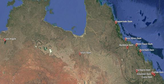
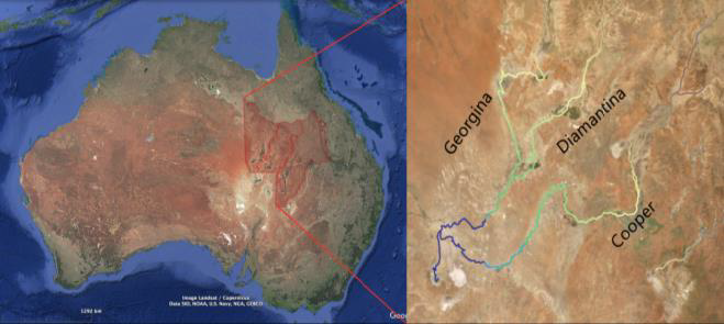
Study Area: 12 lakes and reservoirs were selected across Australia, with a focus on North QLD, according to the criteria: the availability of long-term in-situ water level records, accessibility of SWOT and other satellite overpasses, and their importance in regional water resource management (Figure 1). To address objective 2, three catchments were included in satellite altimetry validation, with a focus on river systems that have high seasonal fluctuations and low gauging capacity (Figure 1).
Figure 1. Map showing the study sites used for SWOT validation. Sites include major dams and inland river systems such as Burdekin Falls Dam and Ross River Dam in Queensland, as well as Lake Argyle in Western Australia.
The right panel highlights the Cooper, Diamantina, and Georgina catchments within the Lake Eyre Basin.
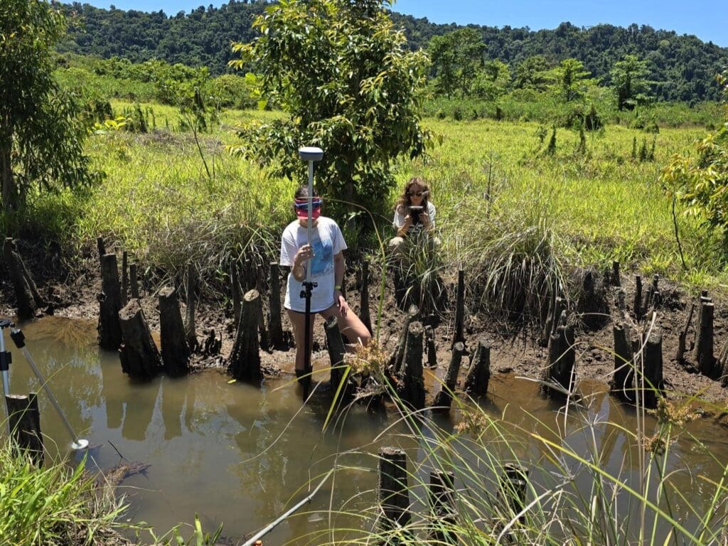
Methods: Satellite ground tracks from SWOT and other altimetry missions were first validated in Google Earth Pro to identify overpass locations across selected sites. Corresponding altimetry data were then downloaded from NASA’s PO.DAAC and the Theia Hydroweb platform. In-situ water level records, obtained from dam operators and the QLD government supplied time series that was aligned with satellite revisit times. To enable direct comparison between satellite-derived and in-situ water surface elevations, all datasets were adjusted to a common vertical reference.
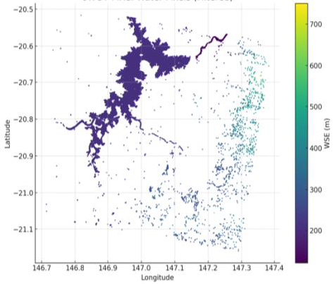
SWOT WSE rasters were visualised in Python and ArcGIS to generate heat maps showing spatial variation in surface water elevation (Figure 2). Statistical comparisons were performed in R to assess accuracy using RMSE, bias, and R2, while residual plots (satellite – gauge) were used to examine deviations during flooding and dry periods.
Figure 2. SWOT-derived Water Surface Elevation (WSE) map for the Burdekin Falls Dam region in Queensland, Australia. Each point represents a pixel from the SWOT Ka-band Radar Interferometer (KaRIn) swath, coloured by WSE (m). The data were subset from SWOT Level-2 High-Resolution Lake/Water Mask products and visualised in Python. This illustrates the spatial pattern and elevation gradient of surface water captured by SWOT during a single satellite overpass.
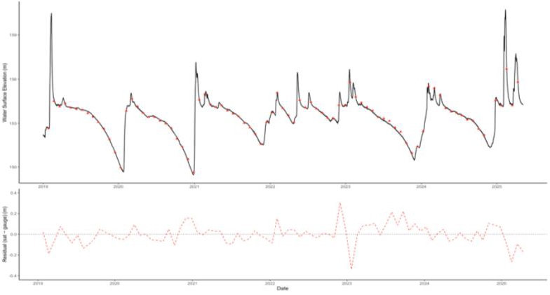
Figure 3. Comparison of satellite-derived and in-situ water surface elevation (WSE) for Burdekin Falls Dam (2019–2025). Satellite data (red) closely match gauge measurements (black), with small residuals (bottom) indicating strong agreement (RMSE = 0.09 m).
Conclusion: SWOT demonstrates strong potential for inland water monitoring of lakes and reservoirs, accurately capturing seasonal water level variation when validated against in-situ gauges. Future work will extend this analysis across additional Queensland catchments to assess spatial performance and understand how satellite accuracy varies under different hydrological conditions. Findings will contribute to improved validation of SWOT altimetry data and help advance the use of satellite observations for national water resource monitoring and management.
Milestone 2
Evaluating the Accuracy of Satellite Altimetry Products for Hydrological Monitoring
Prepared for: TNQ Drought Hub
Author: Lily Lewis, James Cook University
Reliable water level monitoring is critical for drought preparedness, flood management, irrigation planning, and long-term water security across Queensland. However, large areas of inland Australia remain sparsely gauged and logistically challenging to monitor.
This Honours research project evaluated the operational performance of publicly available satellite altimetry products for monitoring inland water surface elevation (WSE) across Queensland lakes, reservoirs, and dryland river systems. The study focused primarily on the Surface Water and Ocean Topography (SWOT) Level-2 High-Rate (HR) LakeSP and RiverSP products, with additional comparison to Sentinel-3 and Hydroweb multi-mission datasets.
Objectives:
The project aimed to:
Quantify the vertical accuracy and bias of the SWOT LakeSP product across Queensland reservoirs.
Assess the performance of the SWOT RiverSP Reach product in multichannel dryland rivers of the Lake Eyre Basin.
Satellite-derived WSE values were validated against in-situ gauge measurements from Sunwater and the Queensland Government Water Monitoring Information Portal.
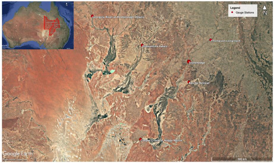
Fig. 1 Spatial distribution of six Queensland Government stream gauge stations across the Georgina, Diamantina, and Cooper Catchments within the Lake Eyre Basin, Australia. In-situ stage observations from these stations were used to assess the accuracy of satellite-derived WSE products. Base map imagery from Google Earth Pro (Version 7.3.6.10441; imagery date [2026]).
Key Findings:
1 – Reservoir Monitoring – High Accuracy and Strong Operational Potential
Across ten Queensland lakes and reservoirs, the SWOT LakeSP product demonstrated strong agreement with gauge measurements.
Weighted Root Mean Square Error (WRMSE): 0.07–0.25 m for water bodies >3 km².
Correlation (R²): ≥ 0.94 at most sites.
Consistent representation of seasonal storage drawdown and refill cycles.
These findings indicate that SWOT LakeSP provides reliable reservoir-scale monitoring capability for medium-to-large storages in Queensland.
Sentinel-3 and Hydroweb lake products also demonstrated strong vertical accuracy (RMSE ~0.31–0.40 m), though with lower temporal resolution.
Implication for TNQ Drought Hub
Satellite altimetry can support near-operational monitoring of lake and reservoir storage dynamics in regions where gauge coverage is limited or where independent verification is valuable.
2 – Dryland Rivers – Highly Variable Performance
In contrast, the SWOT RiverSP product exhibited substantial variability across multichannel, anastomosing rivers in the Lake Eyre Basin:
WRMSE ranged from 0.38 m to 2.79 m.
Performance was strongly site dependent.
Large systematic biases were observed in some reaches.
Errors were associated with:
Narrow channel widths.
Complex floodplain morphology.
Longitudinal slope averaging across ~10 km reaches.
Short-lived flood peaks relative to the ~21-day revisit cycle.
Implications for TNQ Drought Hub
Satellite altimetry alone is currently insufficient for precise flood-stage monitoring in highly dynamic dryland river systems. However, it may still provide strategic, basin-scale trend information when integrated with in-situ gauges.
Operational Considerations:
The research highlights two key implementation constraints:
Data Accessibility & Automation: Operational uptake will require improved automation pipelines to reduce latency and simplify access for end users such as water managers and agricultural stakeholders.
Strategic Value for North Queensland:
This project demonstrates that:
Satellite altimetry can provide centimetre-scale accuracy for reservoir storage monitoring.
Multi-mission integration enhances robustness.
Remote sensing offers a cost-effective complement to physical gauge expansion in remote catchments.
For drought resilience planning, irrigation optimisation, and long-term water resource assessment, satellite derived WSE monitoring represents a scalable tool to support TNQ Drought Hub’s mission of improving water security in northern Australia.
Acknowledgements:
This study was funded by the TNQ Drought Hub. The scholarship funding enabled evaluation of emerging satellite technologies for improving water monitoring capability across Queensland’s dryland systems. Additionally, the author gratefully acknowledges Sunwater for providing dam gauge data.