
Research Questions/Objectives:
How can a remote and mobile terrestrial scanning solutions enhance the accuracy and efficiency of blue carbon and biomass distribution mapping in mangrove ecosystems, wetlands, and green carbon mapping in Mitchell grasslands to support sustainable ecosystem management and climate resilience?
Key Objectives
Brief Description of the Project:
This project will focus on utilising cutting edge remote sensing techniques to analyse and quantify biomass in Australian ecosystems. By applying these methods to diverse environments such as mangroves, wetlands, and grasslands, this research will contribute to understanding carbon dynamics, evaluating land conditions, and supporting informed management decisions. The outcomes will enhance Australia’s ability to address challenges in environmental conservation, agriculture, and climate change mitigation.
Background and Significance of the Research Question to drought risk, vulnerability, preparedness, or resilience:
The proposed research focuses on refining mobile terrestrial scanning methods as a solution to map blue carbon distribution in mangrove ecosystems while also integrating the assessment of green carbon in wetlands and Mitchell grasslands. These ecosystems play complementary and critical roles in mitigating drought risk, enhancing ecosystem resilience, and contributing to global carbon sequestration efforts.
Mitchell grasslands, renowned for their extensive root systems and drought tolerance, serve as vital reservoirs of green carbon. Their ability to stabilise soils, reduce erosion, and sustain biodiversity makes them valuable in buffering against the impacts of drought. By storing carbon in their biomass and soils, Mitchell grasslands contribute to reducing atmospheric CO₂, which in turn helps mitigate climate change and its associated risks, including intensified droughts.
Similarly, wetlands act as hydrological regulators, buffering landscapes against drought by storing and gradually releasing water. They are also crucial in sequestering carbon in their saturated soils, preventing the release of greenhouse gases. Together, wetlands and Mitchell grasslands provide critical ecosystem services that reduce vulnerability to drought, support water security, and enhance landscape resilience.
This research leverages advanced remote sensing technologies, including drone based LiDAR and photogrammetry, to precisely measure biomass, carbon storage, and ecosystem health across mangroves, wetlands, and Mitchell grasslands. By quantifying carbon stocks and identifying areas of degradation, the project will generate actionable insights to inform sustainable management practices, improve drought preparedness, and enhance climate resilience.
The integration of blue and green carbon assessments positions this research as pivotal to addressing global environmental challenges. Its outcomes will strengthen the ability of land managers and policymakers to mitigate drought impacts, preserve vital ecosystems, and support sustainable development in the face of climate variability.
Academic and research experience relevant to the honours project:
By the end of this year, I will have completed a Bachelor of Marine Science at James Cook University, during which I have gained extensive academic and field based experience directly relevant to my proposed Honours project. This bachelor has provided opportunities to develop expertise in mangrove and wetland ecosystems through hands on field trips. During these, I have gained practical skills in advanced technologies, including LiDAR and photogrammetry, as well as foundational techniques such as Dumpy levelling.
I have also cultivated teamwork, problem solving, and independent learning skills through collaborative and individual research activities. My volunteered involvement with TropWATER included conducting topographic and hydrological analyses of wetlands in the Tully River region. This practical experience was complemented by report writing on the Tully River Catchment for university, where I analysed processes such as erosion, flooding, and the impact of anthropogenic activities on the Tully River catchment. These projects deepened my understanding of hydrological and geomorphological processes, as well as the complex interactions within wetland environments.
Additionally, my geology coursework has provided a solid background in field geology techniques, including analysing lithological and stratigraphic characteristics. This interdisciplinary foundation enhances my ability to assess terrestrial and coastal ecosystems comprehensively, bridging geological and ecological perspectives essential for my Honours project.
These experiences have collectively prepared me to undertake advanced research involving the mapping of blue carbon, green carbon and biomass distribution in mangroves, wetlands, and grasslands. My technical proficiency, field expertise, and research background position me well to contribute to and succeed in this honours project.
Principal Supervisor’s skills and experience in relation to this project topic:
Dr. Ben Jarihani is a highly accomplished Water Engineer and Hydrologist with over 20 years of expertise in fields directly relevant to this project, including wetland modelling, geomorphology, soil erosion, hydraulic design, and water resources engineering. His extensive academic background in Irrigation and Drainage Engineering, Water Resources Engineering, and Hydraulic Design underpins a deep understanding of complex aquatic ecosystems like mangroves, wetlands, and grasslands.
Dr. Jarihani’s innovative research approach, demonstrated through his Ph.D. in Spatial Science applied to Hydrological and Hydrodynamic modelling, highlights his proficiency in advanced methodologies such as LiDAR and remote sensing core techniques in this project. His extensive experience in modelling and environmental systems ensures precise guidance in carbon mapping, drought resilience, and ecosystem health assessments.
As both an educator at James Cook University and consultant, Dr. Jarihani’s dedication to advancing knowledge and mentoring students ensures this Honours project is supported by exceptional expertise, enabling the development of impactful solutions for sustainable ecosystem management.
I’m a curious and driven 21-year-old with a long-standing passion for science and the natural world. Originally from Melbourne, I was lucky to spend time in Fiji throughout my childhood, which sparked a deep fascination with the marine environment. With both of my parents working as geologists at Monash University, I was immersed in Earth sciences from an early age—whether through family holidays, after-school visits to the lab, or having to tag along to Uni-Field Trips. Their excitement for the planet’s processes and creation inspired my own journey into environmental science.
During my studies at James Cook University, Townsville, my interest in emerging technologies grew into a specific passion for remote sensing after taking Advanced Marine Geoscience Technologies and Applications. I found spatial science not only intellectually stimulating but genuinely fun—especially as I explored how these tools could help us better understand and manage natural ecosystems. A third-year assignment on how artificial intelligence and remote sensing can quantify blue carbon in mangroves and estuaries solidified my enthusiasm, as I experienced the joy of independent literature-based research and discovery.
In my final semester, I met Dr. Ben Jarihani, a hydrologist with a great work ethic and knowledge in remote sensing. Together, we’re exploring the potential of handheld LiDAR to measure biomass and assess green and blue carbon in coastal and grassland ecosystems—an exciting and innovative field with broad real-world applications across North Queensland, Australia.
Future Career Goals
Looking ahead, I hope to continue working with cutting-edge remote sensing technologies and contribute to the development of simple, accessible methodologies that can be applied across scientific disciplines. I’m eager to collaborate with passionate researchers, work across Australia, and eventually contribute to global efforts in environmental monitoring and climate resilience.
Advanced Remote Sensing for Biomass Estimation and Ecosystem Assessment: Applications in Mangroves, Wetlands, and Rangelands: Applications in Mangroves, Wetlands, and Rangelands in Australia.
By Edward Venn
Supervisors: Dr Ben Jarihani, Dr Nathan Waltham
Overview:
Mangrove, wetlands, and rangelands across North Queensland play a vital role in capturing carbon from the atmosphere, protecting biodiversity, and improving landscape’s ability to bounce back from droughts and climate extremes. However, land managers and researchers need better tools to measure how much vegetation—or biomass—is on the ground to inform decisions about carbon markets, land restoration, and environmental health.
This project is testing new, cost-effective methods using handheld laser scanning (LiDAR), drone imagery, and field observations to measure tree growth and vegetation cover across different landscapes. These faster and more affordable methods could help landholders participate in carbon or nature-positive markets by simplifying how tree growth and carbon storage are reported.
The research took place across rangeland properties at Virgina Park and coastal wetlands/mangroves at Cape Palmerstone. It focuses on improving how remote sensing technology is used to track environmental change, tree growth, and land condition—key information for building resilience to drought and climate change.
Aims:
Methods:
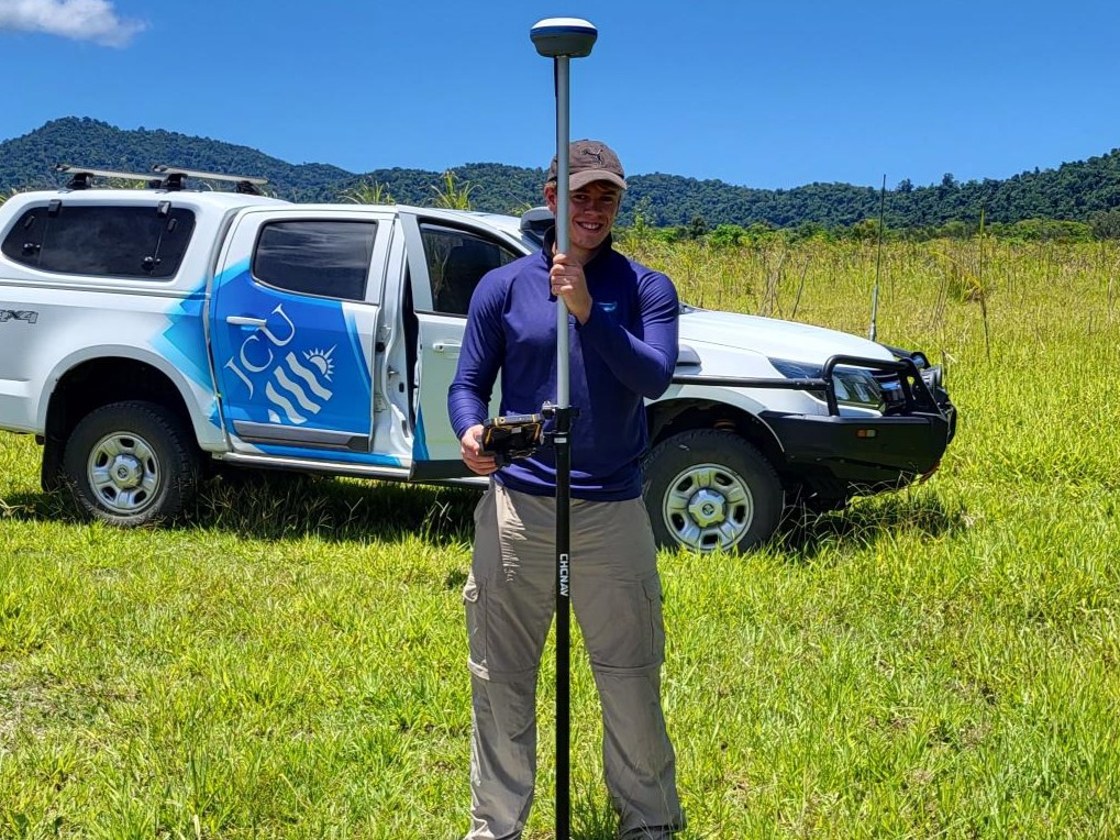
Research surveys were conducted across two sites in Queensland: Sandalwood, Virginia Park (rangelands) and Cape Palmerstone (Wetlands and Mangroves). Data acquisition utilised handheld LiDAR devices to scan the environment creating a detailed 3D Model composed of millions of points (or dots) that represent trees, vegetation and ground. Additional surveying with aerial photography for top-down 3D Model for broader canopy structure assessment for comparison. RTK GPS was additionally used to increase the accuracy of every point in the 3D model up to ~2cm accurate. Ground truthing was performed by manually recording tree parameters within the field to later compare with 3D model derived forestry parameters. In post processing, a comparative accuracy assessment, and 3D model detail over time analysis will be completed.
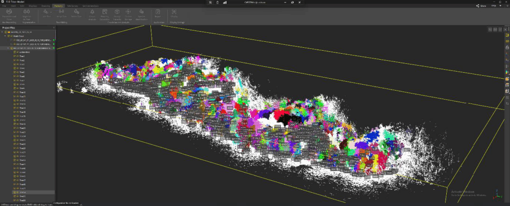
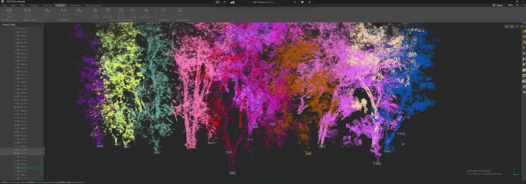
These results demonstrate the effectiveness of handheld LiDAR in capturing detailed 3D data capable of distinguishing individual trees within complex forested systems. By extracting ground points and performing extensive data cleaning—such as manual tree segmentation and outlier removal—an exceptionally detailed forestry model was achieved.
The highly detailed 3D forest model was produced for the Cape Palmerston Wetland Site. Over 900 individual trees were automatically detected, and measured, even in dense vegetation. This final model had over 4 billion data points—showing the power of handheld LiDAR to pick up fine details like tree width, height, and shape. Despite challenges such as a high abundance of vegetation, the approach worked well and delivered some promising initial results.
Conclusion:
Finalised results will deliver detailed biomass maps and ecosystems models for each site within Queensland, guiding conservation and rehabilitation priority assessment. Some complications whilst surveying include dense vegetation interference with LiDAR penetration, providing less detail at distance. Additionally, post processing can struggle with identification of Forestry parameters amongst denser environments, however, can be manually cleaned for analysis. Nonetheless, by improving how we monitor vegetation condition and stored carbon, these tools can help North Queensland’s landholders build resilience to climate change and drought—while also supporting opportunities in carbon and nature-positive markets.
Executive Summary: Practical Applications
Strengths and Limitation of Hand-Held LiDAR for quantifying Vegetation in Tropical Rangelands, Mangroves, & Wetlands in North Queensland.
Introduction
Effective and accurate vegetation data collection is vital for sustaining biodiversity, enhancing carbon storage, and ensuring ecosystem resilience, especially in ecologically significant regions like tropical North Queensland. Ecosystems such as Mangroves, Wetlands, and Rangelands play a crucial role in these processes.
Traditional methods for collecting vegetation data, including ground-based measurements, aerial photogrammetry, and satellite imagery, have limitations in terms of cost, accuracy, scale, and accessibility. Ground-based methods can be time-consuming and limited in scale, while aerial and satellite methods often require specialised expertise and can be expensive. This research explores a new method: hand-held LiDAR (Light Detection and Ranging), and how this technology can be utilised for enhanced vegetation mapping.
Key Applications
The following applications for handheld LiDAR were determined:
Advantages of Hand-Held LiDAR
Limitations of Hand-Held LiDAR
Conclusion
In summary, hand-held LiDAR vegetation mapping presents a valuable tool for the continuous monitoring of vegetation health, carbon stocks, and ecosystem changes. Its ability to survey diverse ecosystems enables the timely identification of degradation, informing proactive management interventions for restoration and conservation. This technology supports the development of targeted management plans, optimising resource use and enhancing biodiversity and ecosystem resilience.
Next Steps
This research will continue, with further data analysis and validation needed to refine methodologies and address the stated limitations. Future work will focus on integrating hand-held LiDAR data with other remote sensing techniques and ground-based measurements to improve accuracy and scalability. These efforts will further enhance the practical applications of hand-held LiDAR for vegetation mapping and environmental management.